Map of France

Les Ferres photos


Find a town, a zip code,
a department, a region... in France
I like Map-France.com !


Les Ferres pictures


Here are the photos of the town of Les Ferres and nearby towns. Les Ferres is located in the department of Alpes-Maritimes in the region of Provence-Alpes-Côte d'Azur. You will find the satellite map of Les Ferres under these photos.

To see photos of nearby towns of Les Ferres, you can try the following links :
   - Photos of Pierrefeu (06910) : town located at 2.98 km
   - Photos of Conségudes (06510) : town located at 3.38 km
   - Photos of Bouyon (06510) : town located at 3.64 km
   - Photos of Bézaudun-les-Alpes (06510) : town located at 4.46 km
   - Photos of Tourette-du-Château (06830) : town located at 5.64 km
   - Photos of Gilette (06830) : town located at 5.76 km
   - Photos of Toudon (06830) : town located at 6.12 km
   - Photos of Revest-les-Roches (06830) : town located at 6.29 km
   - Photos of Cuébris (06910) : town located at 7.14 km
   - Photos of Coursegoules (06140) : town located at 7.25 km
   - Photos of Roquestéron-Grasse (06910) : town located at 7.50 km
   - Photos of Roquesteron (06910) : town located at 7.50 km

 - photos of the department prefecture of Alpes-Maritimes : photos of Nice
 - pictures of others cities of Alpes-Maritimes : Alpes-Maritimes


To see Les Ferres from the sky, here is the satellite map of the town of Les Ferres : Les Ferres map.

I like Les Ferres !


Photos of the town of Les Ferres

These photos taken near the town of Les Ferres can be shown in full screen clicking on the thumbnails. Photos are copyrighted by their owners.

PONT DURANDY - Photo of Les Ferres
PONT DURANDY

BONSON - Photo of Les Ferres
BONSON

LE GABRE - Photo of Les Ferres
LE GABRE

GARE DU PLAN DU VAR - Photo of Les Ferres
GARE DU PLAN DU VAR

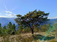
Pin Sylvestre - Photo of Les Ferres
Pin Sylvestre

Panorama - Photo of Les Ferres
Panorama

IMG20250223134510_v1 - Photo of Les Ferres
IMG20250223134510_v1

IMG20250223134517_v1 - Photo of Les Ferres
IMG20250223134517_v1

IMG20250223134818_v1 - Photo of Les Ferres
IMG20250223134818_v1

Himantoglossum robertianum - Photo of Les Ferres
Himantoglossum robertianum

Petasites - Photo of Les Ferres
Petasites

Bois monstre - Photo of Les Ferres
Bois monstre

PXL_20240316_150509621 - Photo of Les Ferres
PXL_20240316_150509621

Fort du Pic Charvet ou Picciarvet - Photo of Les Ferres
Fort du Pic Charvet ou Picciarvet


Les Ferres from the sky


Old photos of the town of Les Ferres

These photos taken near the town of Les Ferres can be shown in full screen clicking on the thumbnails. Photos are copyrighted by their owners.


Other maps, hotels and towns in france


Find another town, zip code, department, region, ...


Quick links Les Ferres :


Back to the menus Map of France :


Make a link to this page of Les Ferres with the following code :


Map of France | Regions | Departments | Cities | Partners | Terms | Contact